Friday, July 23, 2010

The Biker and the Moose

The Biker and the Moose

While we were in Fairbanks, John took a long bike ride out a country road that had been recommended at the store handling the Chena Hot Springs Classic.  As he traveled some 35 miles through wooded areas, he came up over a rise, and there in the road stood a very large moose.  As they made eye contact, John was contemplating his next move.  He figured he could get his bike turned around and headed back down hill in a hurry.  But would it be quick enough!

He was at a T Intersection, and about that time, a young girl drove up in a pick up truck from the other road.  As they both looked at the moose, and she rolled down her window, John asked, “Do you think if I grab his tail he’ll pull me into town?”

The girl laughed.

John then made a sweeping motion with his hand, and said, “Why don’t you go first?”  She turned the corner and as the moose sauntered off, the biker lived to ride another day.

Thursday, July 22, 2010

Mile 0 and 9,411 miles


Today is the big day!  We are in Dawson Creek and Mile 0 on the Alaska Highway.  We have traveled 9,411 miles so far!  And we have virtually driven every highway in Alaska. We came up the Cassiar Highway and we're glad we did!  It meant that we did the Alaska Highway "backwards" and ended where most people begin.  We drove up the Dalton Highway to the Arctic Circle.  We have been to every coastal city accessible by road.  And, if you count our Alaskan cruise a couple of years ago, we have been to every major populated area in Alaska.   We have read so much and learned so much.

There are lots of designations in Dawson Creek to indicate that the road started here.  We went to every one of them.


 Nacho had his picture taken, too.


For some reason, they have put the markers in places where a decent picture is hard to come by.  But, we want to commemorate the occasion, so we completely played tourist.


We even met people at the signs we had met elsewhere along the road.  It was like a reunion. This guy was in Chicken on July 3rd.  He's from Detroit, has been on the road a month and is heading home.  Expects to make the 1800 miles in 3 days!


John threw caution to the wind  and defied the warning signs as he dodged traffic to get out in the middle of a traffic circle to take a picture of this surveyor statue, pointing to the beginning of the highway.


So, we will stay in Dawson Creek for a couple of days, catch up on things, reprovision, catch our breath, and head out once more, this time toward the great National Parks in the Canadian Rockies.  In the meantime, we have accomplished our goal, our dream, to see all of Alaska.


Road Work Keeps Us in the Dark (or Dust)

We have been lucky in that the delays for road work have been minimal.  The longest we have had to wait is about 45 minutes.  We can understand how critical it is to use the short summer to make the repairs.  Most of the roads along here are getting a seal coating, not pavement.  They still have a way to go to learn how to deal with permafrost, but seal coating seems to be working.


Why waste the wait?  I got out of the truck and caught this clover - it's really big up here -- and a butterfly.


We waited quite a while for the pilot car here, and then were almost swallowed up with the dust.  The road grader coming the other way was barely visible.


Fort Saint John - Nacho Makes an Appearance!

We left Prophet River and it was such a beautiful day - high fluffy clouds and bright sunshine.  We saw a Black Bear sunning himself, his back to the road.

On the other side of Buckinghorse River, John saw a pair of birds that we later figured were Sandhill Cranes.  Unusual but plausible, according to the lady at the Fort Nelson Visitors Centre.

The road begins to look like a Virginia or West Virginia Parkway, wide clear cuts, and a shoulder.  Not wide enough to stop on, but a shoulder where we have been used to seeing steep drops.  There are lots of big trucks along here, "hauling butt."

We pass Historical Marker 101 at a town called Wonowon.  Clever!


The farmland begins to open up, with hay fields and rapeseed in full bloom.   They have to have a really short growing season.  In Fort Nelson, there were only  100 days without frost, and it has to be close to the same.

We stopped in Fort St. John and got our groceries and gas.  This is a booming community , population 18,000 with new growth based on newly discovered oil and gas fields.  The community itself was established in 1794, making it the oldest white settlement in British Columbia.  The area was homesteaded in the 1900's, and there are third generation farmers here.  It also received a boost when the Alaska Highway was built, the largest camp in the eastern sector.


We decided to stay in this area tonight, and head back up the road a little ways to Charlie Lake and the Beatton Provincial Park.     The area has some hiking trails (snow trails in winter) and has an unusual variety of plants that are unique to the area.  Just up my alley!


We took a walk down to the lake, and Nacho came out to have his picture taken.  He really didn't like the cold overcast weather in Alaska, and the big animals and steep mountains and valleys were a little scary for him.  But he is liking the fact that it is warmer here, and doesn't seem so threatening.  In fact, he even posed by a cluster of clover, which is very prolific around here.  And I wonder, do bears like clover?  Or just the honey?


Our walk through the woods was wonderful.  It was so quiet, and the trees were beautiful.  Sure enough, I saw some plants I hadn't seen before.


And butterflies!


The whole path was covered with clover.


 We saw some tracks, probably deer tracks.  


 We had a sunset here, and a moon on the horizon, and it is dark now for a few hours at night.
 

Dandelion Check

Just like the Fireweeds, the Dandelions are telling us something about the season.

At the beginning of our trip, the dandelions were everywhere in bright yellow ribbons, or fields, providing fresh greens to the bears who were just emerging from hibernation.

Now they have gone to seed  in great profusion.  They are white ribbons and fields instead.  Given their abundance, no wonder there will be so many along the highways next Spring.

Folded Mountain


Folded Mountain was part of the scenery we saw yesterday, but it was so interesting, i wanted to give it special mention.

"Originally, all of the rock of the Canadian Rockies lay flat on the shallow sea bed of the western continent shelf, where it had accumulated grain by grain for over a billion years.  About 175 million years ago, the continent of North America began to move westward, overriding the Pacific floor, and colliding with offshore chains of islands.

"The continental shelf was caught in the squeeze.  The flat-lyingl layers slowly buckled into folds like those you see here.  A time passed, folded mountain ranges sprang up across British Columbia.  By 120 millon years ago the Rockies were showing above the sea.  They grew for another 75 million years, rising faster than erosion could tear them down -- likely reaching Himalayan heights.  Active mountain building ended in the Canadian Rockies some 45 million years ago.  The peaks have since been eroded to a small fraction of their original size."

A Real Life Safari

A Real Life Safari
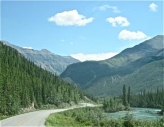
The road from Watson Lake to Fort Nelson is described by the Milepost as one of the most scenic on the Alaskan Highway.  And they weren’t kidding!

Almost immediately, we were seeing Stone Sheep, lots of them,


 and then caribou.


Then, almost immediately we saw a big Grizzly digging for something by the side of the road.  Another car was beside him, and he sauntered off, kind of disgusted.


We are at the beginning of the Rocky Mountain Chain at Lake Muncho.


 This is also the edge of the Muskwa-Kechika Management Area, a 15 million acre area roughly the size of Ireland.  It is called “the Serengeti of the North.”  The management area has mixed used, unlike Denali, which is a National Park and is six million acres.  These areas are so huge; comparing them to whole states or countries is incomprehensible.  

Muncho Lake has a runoff filled with copper oxide, which gives it beautiful green and blue hues.  It started to rain, and it was even pretty with big drops breaking the surface.


The mountains here are boulders and gravel, with huge alluvial fans and gravelly riverbeds.


 The layers of mountains beyond mountains are vast.  The Alaska highway has a lot of different looks along here – narrow clear cuts, wide ones, ones that have been cropped of their vegetation, others that have been allowed to grow higher.


We made a lot of stops along here to take pictures of the caribou and sheep.
See the sheep right in the middle of the picture, just below the last tree branch on the right.

  One steep mountain pass provided the perfect habitat for the sheep, the kind you always see in National Geographic.  John was able to take a lot of pictures of the sheep as they blended into their environment and watched us from on high.  Can you see the baby in this picture? He's right beside the bigger sheep, to the right,  about shoulder high.


Then when we reached the summit, the land began to level out.  We paralleled the Rockies off to our left, as the land began to look like high river valleys.  There were meandering streams, and we saw beaver dams on clear calm ponds that dropped off the horizon.

We saw an elk, a cow with a beautiful shiny coat, but she was on the run and out of sight before we could get her picture.

Roadwork and stoppages for pilot cars brought a reality to the day.  The driver in front of us at one stop got out to inspect his rig in his pajamas and slippers!  The land begins to look like it could be farmland, and some houses were visible.   This is so unlike the areas we have been through where there is nothing, and then a crossroads.

We reach Fort Nelson, originally a Hudson Bay trading post. Three major rivers converge in this valley and the water table is very high. There are wooded areas of aspen, poplar and white spruce.  The Hudson Bay Company built a trading post here because they wanted to drive out the independent fur trappers who were paying higher prices to the natives.  Fur trapping still exists here, for beaver, wolverine, weasel, wolf, fox, lynx, mink, muskrat and marten.  Moose are still an important food source for the First Nations people here, who are Dene, part of the Athabascan tribe.  They came here about 1775 from the Great Slave Lake in the Northwest Territory. In 1920, there were 200 "aboriginals" and a few white men.

We had dinner in Fort Nelson and decided to drive on.  The evening light made everything look pastoral, only there are no farms here, only trees.  We saw more beaver dams and a black bear foraging by the road, his head down and away from us, unperturbed.

It was getting late, and we found a place to pull off the road at an old Provincial Campground at Prophet River, which is no longer operational.  It is right on an emergency airstrip (no drug runners, we hope.) We are alone out here, and it feels kind of spooky to me, neat to John.   This is one night I want to pass quickly.